 |
 |
 |
 |
Our local sandstone is often red, as we know, due to the presence of ferric iron minerals, also responsible for the colour of the soil. These sandstone beds were laid down in the Devonian period, about 375 million years ago.
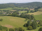
In geological terms Hope Mansell lies within a small tectonic dome, about 4km in diameter, from Howle Hill to Wigpool. A dome is a feature consisting of symmetrical anticlines or folds in the Earth’s surface with an arch-like form.
Before erosion, domes are distinct, rounded protrusions on the Earth’s surface. However, if you slice through parallel to the Earth’s surface, a dome features concentric rings of strata. Consequently, if the top of a dome has been eroded flat, the resulting structure from above appears as a bullseye, with the youngest rock layers at the outside, and each ring growing progressively older moving inwards.
These strata would have been horizontal at the time of deposition, then later deformed by the uplift from the tectonic plates shifting. The shape we see today is due to erosion of the softer, less resistant Upper Old Red Sandstone marls. The smaller hill at the centre of the valley (the Lea Bailey Inclosure) is harder Old Red Sandstone, while the partially encircling ridge reaches 279m high and is formed of Carboniferous Limestone and Upper Coal Measures.
The history of Hope Mansell has been shaped by the physical geography – its enclosed and isolated situation – and, as importantly, by its position on the edge of the Forest of Dean. "Forest" was a legal term, applied to an area owned by the Crown and maintained effectively as a game reserve for hunting.
The landscape in our valley bears the imprint of a more extensive Forest of Dean. Place names include Perlieu Wood for example, purlieu being a wood outside the forest, legally deforested but subject to some of the forest law; Lea Bailey, a bailiwick being a large administrative district of the forest; and the field name "the riddings": land cleared or rid of trees.
The lime kilns up Chestnut Lane (or Kiln Lane as we all call it) next to Yew Tree House date from around or after 1540, but flints from Mesolithic times and Roman pottery and roof tiles have also been found within the parish. And there really are traces of an early medieval moat at Moat Farm!
CME
First published March 2018