 |
 |
 |
 |
This is turning into quite the mini-series. Here is an additional piece sent in by Allan Ockenden, following on from Mary Freeman's article.

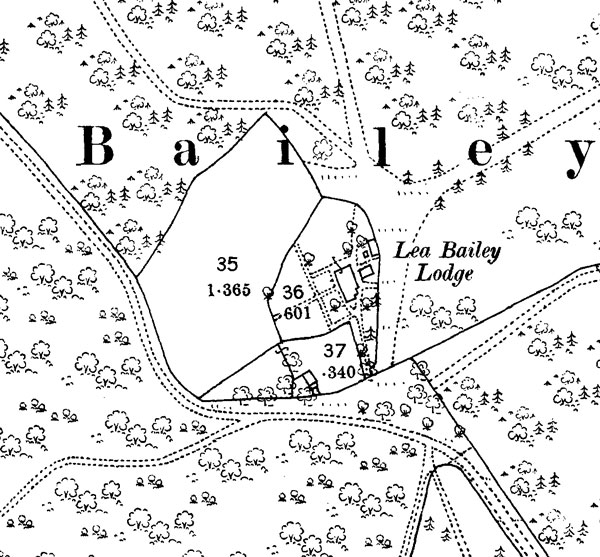
Further to earlier articles about Lea Bailey Lodge, the 1889 1:2500 OS sheet shows the lodge in great detail. The garden around the house is shown together with outbuildings and a paddock in all about 2.3 acres. The layout of forest rides has changed little in the last hundred years and the position of the lodge is easily located today. Careful inspection at the site can still reveal remnants of the old boundaries and the footings of the demolished buildings beneath the undergrowth.
The Lodge was built around 1810 in response to the Parliamentary Act of 1808 "for the increase and preservation of timber in Dean and New Forests". It was one of 24 so called 'Glenbervie lodges' which were erected in various parts of the Forest under the aegis of the then Chief Commissioner for Woods and Forests, Lord Glenbervie who was Surveyor General between 1803 -10.
The lodge would almost certainly have had an inscribed stone above the doorway similar to the one shown in the photograph at Stapledge. This has alas was lost with the demolition of the lodge in the 1930s.
By the end of the 18th century the timber reserves in the Lea Bailey, as with many other parts of the Forest, had become depleted and the area subject to encroachment with the building of many cottages and the annexation of small plots of land. Glenbervie oversaw a programme of re-afforestation and the creation of substantial new fenced inclosures in order to protect this new planting and the deter further encroachment. The new foresters Lodge was sited in the corner of a new 169 acre inclosure which occupied the northern part of the Lea Bailey, and the surrounding ditch and bank can still be traced in the woods today. By the 1860s two other inclosures totalling 136 acres had been established in the southern part of the woods bounded, in part with a stone wall, the remnants of which can also still be found, particularly along Elm Lane.

Allan Ockendon - Newtown